Tag Archives: Asturias

Fuentes del Narcea y del Ibias Natural Park

  • Region: Asturias
  • Province/ Main town: Cangas del Narcea
  • Declared a Natural Park: 2002
  • Park surface area: 47,589 hectares
  • Partially declared a place of Community importance of Fuentes del Narcea and Ibias.
  • Place of Community importance of Munieḷḷos.
  • Partially declared a Special Protection Area for the birdlife of Fuentes del Narcea, Degaña and Ibias.
  • Special Protection Area for Birds in the Munieḷḷos area. (ZEPA)
  • Declared a Muniellos Biosphere Reserve.
  • Declared a Biosphere Reserve in 2003.
  • Cueto de Arbás Partial Natural Reserve.
  • Villages and towns in the area: Cangas del Narcea, Degaña and Ibias

Points of interest

The Fuentes del Narcea, Degaña and Ibias Natural Park (in Asturian Parque Natural de les Fontes del Narcea, Degaña y Ibias ) is a protected natural area located in Asturias. It borders to the south with the Cantabrian mountain range in Cangas del Narcea, and to the east with the Somiedo natural park.

The park takes its name from the Narcea and Ibias rivers. The natural park encompasses the upper reaches of these two rivers including tributaries from the Collado Alto to Rengos. Within the park area there are the Degaña, Rañadoiru, Obayu, Cagamosa, Caniellas, Soldepuestu and Xenestosu mountain ranges.

This video from the Asturian tourist board has some great sights and sounds

Perhaps the he most important peak is El Cueto de Arbas (2006 m) which gives its name to the extra natural reserve area. Here we can can find beech and oak trees that are well represented on its slopes along with subalpine vegetation. There is also an extensive hydrographic network that has numerous lagoons and peat bogs such as Arbas, Chauchina, Fuentes del Narcea, Reconco, Chagueños and Changreiro that host a rich animal and plant life.

The natural park also has a large number of valleys among which the Degaña valley stands out.

Find a hotel in the Fuentes del Narcea y del Ibias Natural Park

Booking.com

A habitat of wild forest landscapes

In the park there is one of the largest oak groves in Europe called the Munieḷḷos forest which is located in the valley of the same name. The most important beech forest found within the park is Valle De Hermo with an area of ​​10 km. The mixed woodland also contains birch, chestnut, poplars and many of the other common trees of the Atlantic forest habitat.

Mammals are well represented with the Cantabrian Bear at the top of the list along with. Iberian wolf, roe deer, wild boar and chamois. Also look out for fox, genet, stone marten, wild cat and badger.


Information/Visitors Centers

(Please note that all opening times are often changed without prior notice but are normally open during the mornings and most weekends)

Casa del Parque Natural de las Fuentes del Narcea, Degaña e Ibias (Courias)

Located in the old stables of the Monastery of Corias this is one the most important information centres and a major entry point to the Natural Park. In addition to housing the natural park administration offices it also has an exhibition space where you can learn about the main characteristics of this extensive territory.

There are also interesting remains of an old cocoa mill belonging to the monastery that was found and partially restored during the buildings restoration.

Aula de la Naturaleza del Parque Natural de las Fuentes del Narcea, Degaña e Ibias (San Antolín)

In this museum you can explore the culture, traditions, architecture and crafts, of the area through fascinating objects, stories, exhibitions and workshops. There is also a fascinating re-creation of a traditional building showing how people lived and worked centuries ago.

The landscape Interpretation Center

The landscape Interpretation Center of the Fuentes del Narcea, Degaña and Ibias Natural Park is located in Cerredo (Degaña) in a traditional house called Casa Florencio. The house dates from the 19th century.

With its slate roof and a chapel the house represents the traditional architecture of the area. The house holds temporary exhibitions and is also the official tourist office for the village of Degaña.

Centro de Recepción de visitantes de Muniellos (Las Tablizas)

Located in the Muniellos forest in a restored quarry, this is a place where you can learn more about the nature of the Muniellos forest and surrounding areas. There are exhibitions, a cafeteria, a recreational area and two viewpoints accessed by footpaths with stunning views.

Centro de Recepción de Visitantes de Muniellos

This is the ebtry point for the Natural Reserve of Muniellos. Information and a small exhibition showing the flora, fauna and landscape of the area.

To walk the route that runs through the Muniellos Reserve, you have to request a permit. (Only 20 people a day are allowed in to preserve its condition). You can request a permit here. (Scoll to the bottom and click on “Iniciar solicitud “) Or you can try calling 985 27 91 00 for a permit.

See also the official website for tourist information here. (Spanish mostly)

Walking and Hiking in the Fuentes del Narcea y del Ibias Natural Park

There are a lot of hiking trails in this natural park and some are listed below. You can google them to find out more or visit the information centres mentioned above.

  • PR.AS – 8 – Ruta de las llagunes “tixileiras”.
  • PR.AS – 9 – Ruta de la Braña de Llanelu.
  • PR.AS – 7 – Ruta de la Hucha.
  • PR.AS-132 – Ruta Bosque de Moal.
  • PR.AS-168 – Pomar de las Montañas.
  • PR.AS-23 – Ruta del Pico Miravalles.
  • PR.AS-24 – Ruta de Faena.
  • PR.AS-26 – Ruta das pallozas de Santiso.
  • PR.AS-28 – Ruta del Chao da Serra.
  • PR.AS-29 – Ruta del Túmbalu de Seroiro.
  • Ruta Bosque de Muniel.los.
  • Ruta Cueto d’Arbas.
  • Ruta Cueva da Osa – Ruta del Desfiladero de Bustelín.
  • Ruta de las Brañas.
  • Ruta de las Llagunas de L.langreiru.
  • Ruta del Cabril.
  • Ruta Llagunas de Fasgueo.
  • Ruta Llagunas de Tablao.
  • Senda Moura.
  • SL.AS-19 – Ruta del Puertu de Lleitariegos.
  • Ruta al Pico El Alcornon de Busmori
  • Ruta al Pico El Picón
  • Ruta al Pico El Miro
  • Ruta al Pico del Oso
  • Ruta por el Camín Real ( Cerredo- Degaña)
  • Ruta al Pico Tachetas y Pena Mayor
  • Ruta ascensión al pico El Cueto de Arbás

Tourist routes by car

Again, find out more about driving routes in the Fuentes del Narcea y del Ibias Natural Park by visitng the information centres mentioned above.

  • Ruta de los Cunqueiros.
  • Ruta de los Puertus.
  • Ruta de Sierra.
  • Ruta del Xardón.
  • Ruta del Oro.

Guided tours and activities in Asturias

Ronda Today

Everything you need to know before you visit Ronda “The city of dreams” in Andalucia. https://www.rondatoday.com/

Visit Cádiz

Planning on visiting Cádiz? Tourist information. Monuments. Hotels. Activities. City guides: https://visitingcadiz.com/

The Caminito del Rey

Find tickets for the Caminito del Rey: https://www.caminodelrey.es/

Wildside Holidays – Spain

Take a trip on the Wildside! Discover the wildlife and nature of Spain, its Natural and National Parks and find the top wildlife, activity and walking holiday companies.

Iberia Nature Forum

Struggling with identifying those bugs and beasties? Why not check out the Iberia nature Forum! https://iberianatureforum.com/

Redes Natural Park

  • Region: Asturias.
  • Park surface area: 37,700 hectares.
  • Declared a Natural Park: 1996.
  • Declared a UNESCO Biosphere Reserve; 2001.
  • Site of Community Importance.
  • Special Protection Area for Birds (ZEPA).
  • Towns and villages in the area: Caso, Sobrescobio.

Points of interest

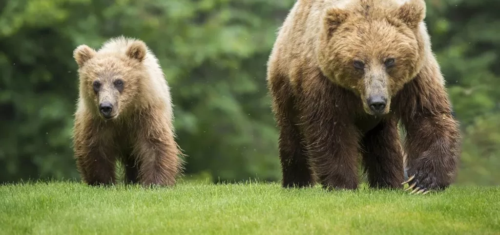
The Redes Natural Park is mostly covered by large wooded areas, among which its endless beech forests are striking. It is located in the eastern / central area of ​​Asturias. At high altitude there is evidence of glacial erosion that occurred during the Pleistocene period. This glacier modeling allows you to see wide glacial cirques and valleys.

This is an impressive karst landscape with many chasms and sinkholes and there are also high moorlands, pastures and also chestnut plantations. Redes Natural Park is home to all the characteristic species of the north of the peninsula such as the brown bear, capercaillie and Iberian wolf as well as the largest populations of chamois and deer in Asturias.

Fantastic promo video by Turismo Asturias about the Redes natural park

One of the most visited places in the park is the plain of Brañagallones. here you can find the typical braña vaqueira (mountain shelter for farmers and animals) where there is now a mountain refuge for hikers.

Continue reading Redes Natural Park

Somiedo Natural Park

  • Region: Asturias
  • Province / Main town: Somiedo
  • Declared a Natural Park: 1988.
  • Declared the Somiedo Biosphere Reserve by UNESCO: 2000
  • Park surface area: hectares: 29,122 hectares.
  • Towns and Villages: Somiedo, Belmonte de Miranda and Teverga.

Points of interest

The Somiedo Natural Park is a protected natural space that is located in the central area of ​​the Cantabrian mountain range, Asturias. It also has the protection as a “Place of Community Importance” and Special Protection Area for Birdlife.

The area has also become famous as a starlight destination. The Starlight Foundation is a non-profit organization that was founded in 2009 to promote the protection of the night sky and the development of “astrotourism” and there is an ever growing list of starlight destinations in Spain to visit.

Continue reading Somiedo Natural Park

Ponga Natural Park

  • Region: Asturias.
  • Declared a Natural Park: 2003.
  • Park surface area: 20,533 hectares.
  • Place of Community Importance of Ponga-Amieva.
  • Ponga-Amieva Special Conservation Area.
  • Special Protection Area for Bird (ZEPA)
  • Peloño Partial Nature Reserve.
  • Towns and villages in the Area: Ponga, San Juan de Beleño, Sobrefoz

Points of interest

Ponga Natural Park is located in the central-eastern area of the Cantabrian Mountains entirerly within the environs of the town of its namesake, Ponga.

The most noteworthy of its mountain ranges comprises the sector of the Cantabrian mountains forming its southern boundary, constituting the watershed between the basins of the Rivers Sella and Duero and home to peaks such as El Abedular (1,813 m), Les Pandes (1,879 m) and Ten Crag (2,142 m), among others. Ponga Ridge constitutes its western boundary, with noteworthy peaks such as Maciéndome (1,899 m) Tiatordos (1,951 m) and Campigüeños (1.838 m).

The most important rivers in the area are the Sella, which runs through the eastern part of the territory to continue its course through Amieva and the Ponga, which runs from south to north. The local tributaries of the River Sella include the Roabin and the Rivers Mojizo, Porciles and Santa Bustia. The most important tributaries of the River Ponga are the Taranes and El Valle Moro. Most of these river valleys are narrow with sheer slopes, the most spectacular cases being those of Ponga Gorge and Beyos Gorge.

The economic importance of the forest in the recent history of Ponga and its inhabitants has always been present since ancient times. Forests such as Peloño and Semeldón were subjected to massive logging on several occasions for shipbuilding and to meet the demand for fuel in forges and ironworks, fed with charcoal. To a lesser extent, the wood burned in the limekilns to obtain lime also significantly influenced the decline of the forest masses in the region.

Thankfully logging is now highly controlled or banned and the natural park is a safe haven to the wildlife that inhabit it.

Find a hotel in the Ponga natural Park

Booking.com

Flora

More than a third of the Ponga Natural Park is made up of mature forests such as oak, birch, ash, maple and alder and the main forest in the area is called Bosque de Peloño. This is located in the southeast of the natural park and covers approximately 1,500 hectares.. Beech, however, is most predominant and together with other numerous forests scattered around the park they represent places of great importance since they are a vital habitat for emblematic and endangered species.

Along with these wooded formations, thickets and plantations alternate, reflecting the human management of the landscape. Among the bushes, heaths, gorse and broom stand out and among the plantations, chestnut trees (especially in the central area of ​​the park).

Among the flora of the Park it is worth mentioning the presence of the Asturian daffodil (Narcissus asturiensis) and the gentian (Gentiana lutea) both cataloged as species of special Interest in the Regional Catalog of Threatened Flora of Asturias.

Fauna

The excellent state of conservation of the habitats in this natural park makes it possible to find some of the most emblematic species of the Cantabrian mountains. Among the mammals, the otter (Lutra lutra) and the desman (Galemys pyrenaicus) Also there is the occasional presence of the brown bear (Ursus arctos).

The Ponga Natural Park is also included in the Natural Network as a Special Protection Area for Birds (ZEPA). This is due to a rich and diverse bird fauna mainly composed of forest species such as the Cantabrian grouse (Tetrao urogallus cantabricus) and the middle spotted woodpecker (Dendrocopos medius) or birds of prey such as the golden eagle (Aquila chrysaetos), griffon vulture (Gyps fulvus ) and goshawk (Acipitter gentilis).

Guide activities nearby with Get Your Guide

Information/Visitors Centers

Ponga Natural Park Interpretation centre

The Interpretation Center of the Ponga Natural Park, in the town of San Juan de Beleño, offers visitors an interesting tour and covers themes of human history in the area, towns, traditions and crafts as well as the expected exhibitions on the natural history, flora and fauna of Asturias.

If you are interested in hiking and walking in the area then this office has a good selection of local maps and guides.

Opening Times
Spring and Summer – Monday to Saturday 9 am to 2 pm and 4 pm to 7pm. (Sundays 9am to 2 pm and 4 pm to 6 pm).
Autumn and Winter – Tuesday to Saturday 9am to 2 pm and 4 pm to 6 pm (Sundays 9 am to 2pm) Closed on Mondays

Website: https://www.ponga.es/parque-natural


The Grazalema Guide

The best way to see all our web projects in one place is over at the Grazalema Guide.

The Grazalema Guide – Tourist Information Portal for the Sierra de Grazalema, Wildside Holidays, the town of Ronda and the Caminito del Rey.

https://grazalemaguide.com/