Tag Archives: Natural Parks in Castilla y Leon

Montaña Palentina Natural park

  • Region: Castilla y Leon
  • Province: Palencia
  • Declared a Natural Park: (Fuentes Carrionas and Fuente Cobre-Montaña Palentina Natural Park) 1992
  • Renamed and expanded: (Montaña Palentina Natural park) 2000
  • Park surface area: 78,360 hectares
  • Towns and villages: Aguilar de Campoo, Brañosera, Castrejón de la Peña, Cervera de Pisuerga, Dehesa de Montejo, La Pernía, Polentinos, Triollo, Velilla del Río Carrión, San Cebrián de Mudá

Points of interest

The Montaña Palentina Natural Park (formerly called Fuentes Carrionas y Fuente Cobre-Montaña Palentina Natural Park) is a protected area located in the north of the province of Palencia. The Palentina Mountain range is home to the Fuentes Carrionas and Fuente del Cobre which are the sources of the Carrión and Pisuerga rivers.

This is a space of great natural, landscape, fauna and botanical value. It has the most northern mass of junipers in Europe, together with endemic species from the Cantabrian Mountains such as the Cantabrian Artemis and the Echium cantabricum.

Continue reading Montaña Palentina Natural park

Hoces del Alto Ebro and Rudrón natural park

  • Region: Castilla y Leon. (Burgos)
  • Park surface area: 45,767 hectares.
  • Declared a Natural Park: 2008.
  • Special Protection Area for Birds (ZEPA).
  • Towns and villages in the area: Alfoz de Bricia, Basconcillos del Tozo, Los Altos, Sargentes de la Lora, Tubilla del Agua, Valle de Manzanedo, Valle de Sedano, Valle de Valdebezana, Valle de Zamanzas
Points of interest

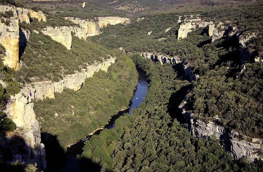
The Hoces del Alto Ebro y Rudrón natural park is located in the northwest of the province of Burgos and presents a landscape of great beauty. Narrow valley bottoms wedged between steep gorges and cliffs are crossed by the Ebro and Rudrón rivers. These are in contrast to the extensive, almost flat moorlands located at higher altitudes.

A short clip showing the diverse landscape of the Hoces del Alto Ebro y Rudrón natural park
Hoces del Alto Ebro and Rudrón natural park

The Ebro River crosses the north of the province of Burgos from Orbaneja del Castillo to beyond Miranda de Ebro for 150 km in a succession of canyons (hoces) alternating with open valleys, as well as other natural elements in the surroundings that constitute an area of natural interest. The route of the river goes from west to east, but very sinuous, either because it ends up crossing a mountain massif in the most favorable place (dissolution of limestone rocks mainly) or because it forms meanders in the valleys.

Find a hotel close to the Hoces del Alto Ebro and Rudrón natural park

Booking.com
The Las Loras UNESCO Global Geopark

The nearby Las loras UNESCO Global Geopark is halfway between the Castilian Plateau and the Cantabrian Mountain Range. This transitional location gives the region the typical weather and environmental features of the surrounding regions. It also possesses a wide range of environments and biodiversity, with both Euro-Siberian sites as well as Mediterranean sites. In addition, the unusual topography resulted in a peculiar landscape where limestone cliffs and significant high altitude moorlands alternate with gorges and deep valleys created by the river system.

The Las Loras UNESCO Global Geopark
Waterfalls in the The Las Loras UNESCO Global Geopark
Continue reading Hoces del Alto Ebro and Rudrón natural park

Sierra de Gredos Regional Park

  • Region: Castilla y Leon
  • Province: Ávila
  • Declared a Regional Park: 1996
  • Park surface area: 86,236 hectares.
  • Z.E.P.A -Special Bird Protection Zone
  • Local towns and villages El Arenal, Arenas de San Pedro, Bohoyo, Candeleda, La Carrera, Cuevas del Valle, Gilgarcía, Guisando, El Hornillo, Hoyos del Collado, Hoyos del Espino, Los Llanos de Tormes, Mombeltrán, Nava del Barco, Navalonguilla, Navalperal de Tormes, Navarredonda de Gredos, Navatejares, Puerto Castilla, Santiago de Tormes, San Juan de Gredos, San Martín del Pimpollar, Solana de Ávila, Tormellas, Umbrías, Villarejo del Valle, Zapardiel de la Ribera and San Esteban del Valle.

Points of interest

The Sierra de Gredos Regional Park is situated in the southern part of the province of Ávila and encompasses the highest altitudes of the mountains. The highest point of the Sierra de Gredos and also central Spain is the Pico Almanzor at 2,592 metres.

The Sistema Central mountain chain, predominately of granite rock, cuts east to west from Madrid province to Portugal. The Sierra de Gredos is a part of this formation which stretches for nearly 140km running through the provinces of Madrid, Ávila, Salamanca, Toledo and Cáceres.

This once glaciated region has been gradually eroded and molded by the action of ice and water. At lower altitudes deciduous and evergreen forests move up to slopes covered in broom, to alpine meadows and higher still to exposed rock which grows lime coloured lichens, often snow covered. The range of habitat types covers alpine meadows, glacial cirques, glacial lake, moraines, rocky crags, river gorges and sub tropical slopes.

The area has also become famous as a starlight destination. The Starlight Foundation is a non-profit organization that was founded in 2009 to promote the protection of the night sky and the development of “astrotourism” and there is an ever growing list of starlight destinations in Spain to visit.

Find a hotel in the Sierra de Gredos Regional Park

Booking.com Continue reading Sierra de Gredos Regional Park