Posets-Maladeta Natural Park

Posets-Maladeta Natural Park
  • Region: Aragón
  • Province: Huesca
  • Declared a Natural Park: 1994
  • Park surface area: 33,000 hectares
  • Local towns and Villages: Benasque, Gistaín, Montanuy, Sahún, San Juan de Plan
Points of interest

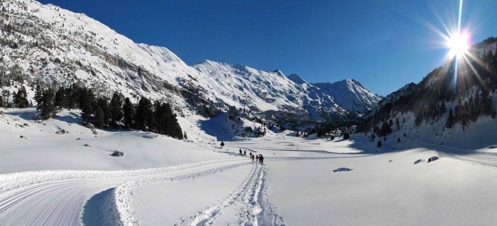
The Posets-Maladeta Natural Park is a protected natural area located in the north of the Ribagorza region and northeast of Sobrarbe in the province of Huesca. It encompasses two of the highest massifs in the Pyrenees. Heights range from 1,500 m in the valley to 3404 m at the summit of Aneto which is the highest peak in the Pyrenees. The moraines and mountain lakes of Vallibierna, Cregüeña, Batisielles, Millares and Remuñe are home to flora and fauna of the high mountain climate. Along with the Benasque valley there are other valleys within the natural park such as the Estós and Vallibierna.

Read more

Ordesa y Monte Perdido National Park

The Ordesa Valley

Above Image By Heparina1985 – Valley of Ordesa, Ordesa y Monte Perdido National Park, Spain

  • Region: Aragón
  • Province: Huesca
  • Declared a Natural Park:1918
  • Park surface area: 15,696 hectares (extended to this in 1982)
  • UNESCO 1997 (Ordesa-Viñamala)
  • Zona de Especial Protección para las Aves.

Points of interest

The Ordesa y Monte Perdido National Park is an area of dramatic landscape, overseen by the peak of Monte Perdido at 3,355m, found within the Pyrenean mountain range that forms the border between Spain and France.

Arid limestone mountain peaks contrast with deep ravines and lush green valleys. Glaciers have scoured the mountains and there are four fast flowing rivers that fall into the Spanish side. Their valleys are named Ordesa, Pineta, Añisclo and Escuaín.

The original park, created in 1918, only covered the Ordesa valley with one of the intentions being to preserve the Pyrenean Ibex, a type of wild mountain goat. Sadly the last of this species died in January 2000.

Read more

Moncayo Natural Park

The Moncayo Natural Park is a protected natural area located in the province of Zaragoza on the border with the province of Soria.
  • Region: Aragón
  • Province: Zaragoza
  • Declared a Natural Park: 1978
  • Park surface area: 11,144 hectares
  • Towns and Villages: Añón, Calcena,Litago, Lituénigo, Purujosa, San Martín de la Virgen de Moncayo, Talamantes, Tarazona and Trasmoz

Points of interest

The Moncayo Natural Park (once called the “Dehesa del Moncayo Natural Park”) is a protected natural area located in the province of Zaragoza on the border with the province of Soria. It occupies part of the regions of Aranda, Campo de Borja, Tarazona and Moncayo. Moncayo itself is a 15 km long and about 7 km wide mountain chain and the highest summit, San Miguel (2,314 m), is the highest point in the 500 km long sistema Ibérico. The Moncayo massif also includes two other peaks that are almost identical and are located close together. They are the Cerro San Juan (2,283 m) and Peña Lobera (2226 m).

The area has quite a few walking / hiking routes and one of the most famous starts from the village of San Martín de la Virgen de Moncayo and finishes at the village of Agramonte. (See information centres below)

The area has also become famous as a starlight destination. The Starlight Foundation is a non-profit organization that was founded in 2009 to promote the protection of the night sky and the development of “astrotourism” and there is an ever growing list of starlight destinations in Spain to visit.

Find a hotel in the Moncayo Natural Park

[booking_product_helper shortname=”moncayo natural park”]


Read more