Tag Archives: Natural Parks in Galicia

Monte Aloia Natural Park

  • Region: Galicia
  • Province: Pontevedra
  • Declared a Natural Park: 1978
  • Park surface area: 746 hectares
  • Towns and villages: Tuy

Points of interest

Located in the south of Pontevedra province the Monte Aloia Natural park (the first natural park in Galicia) is basically the summit of the Sierra de Galiñeiro mountain range.

There are prehistoric and Roman remains in the area and the fascinating local history is surrounded by legends such as this is place of the mythical mountain called Monte Medulio where the collective suicide of the Celtic tribes rather than falling into the hands of the Romans took place.

Forestry engineer Rafael Areses Vidal was born in Tui in 1878 who died in 1953. He was a man born before his time and transformed this landscape a hundred years ago with a reforestation project that included autochthonous vegetation as well as other exotic species, such as cypress, spruce and Lebanon cedar. He promoted the reforestation of Mount Aloia, creating in 1906 the Viveiro Forestal de Areas on Mount Seixos Albos (the first woodland plant nursery of its kind in Galicia) and In 1909 he started the first official plantations in Oia, Tui , A Guarda (on the mountain of Santa Trega), Baiona and Ponteareas. The supplies from his forest nurseries promoted the extension of the pine plantations in the whole of Galicia.

His conception of a mountain with a space of public enjoyment linked to forest exploitation and the consequent economic development, is an idea very close to the current concepts of tourism and environmental sustainability .

Find a hotel close to the Monte Aloia Natural Park

Booking.com

Walking and footpaths

The trails here are very easy for walkers. The Muíños do Tripes trail is made up of walkways and wooden bridges alongside some interesting restored mills. The Rego da Pedra route can be started at the Forest House (information centre) itself or in the village of Frinxo and follows an old stone waterway built centuries ago to carry water to the crops. The botanic trail also starts for the interpretation centre and has plenty of information panels explaining the plant diversity andhelp with identifying the species in the area.

Other easy walks in the area are. (Ask in the information Centre)

  • Senda das Udencias 600 m 30 min LINEAR
  • Rego de Pedra 2,4 Km 1,30 h CIRCULAR
  • Muíños do Tripes 2,5 Km 1,30 h CIRCULAR
  • Muíños de Paredes 6,5 Km 3,30 h LINEAR
  • Castro Alto dos Cubos 4,5 Km 2 h CIRCULAR
  • Cabana-Cabaciña 2 Km 1 h CIRCULAR
  • A Muralla 2,5 Km 2 h CIRCULAR

Molinos del Folón y del Picón

Located in the municipality of El Rosal, the Folón and Picón mills (in Galician muíños do Folón e do Picón ) are a group of 60 cascading mills, documented as early as the 18th century. They are a characteristic legacy of the rich ethnographic heritage of the Bajo Miño region and as such have been declared Assets of Cultural Interest by the Government of Galicia.

Molinos del Folón y del Picón

The 60 mills are divided into two sections that receive two different names

  • The Folón mills: 36 buildings on the slope of the Folón river.
  • Los Molinos del Picón: 24 buildings on the slopes of the Picón River.

For walking the route of the mills see wikiloc: https://www.wikiloc.com/hiking-trails/pr-g-94-ruta-dos-muinos-do-folon-e-o-picon-2961623


Information/Visitors Centers

Centro de Interpretación de la Naturaleza ”Casa Forestal” Enxeñeiro Areses

Directions: From Tui on the Gondomar road (PO-340) 1 km. detour to the right going up 5 Km. towards the top of Monte Aloia.

The interpretation centre for the Monte Aloia Natural Park is housed in an old forest house. The interesting design of the building is the work of the aforementioned forest engineer Rafael Areses who built it in 1921.

Monte Aloia Natural Park - Interpretation Centre
Monte Aloia Natural Park – Interpretation Centre

There are detailed information panels and a lot of information about the endemic and also introduced species of exotic plants.

The official tourism website is here: https://www.turismo.gal/que-visitar/espazos-naturais/parques-naturais/monte-aloia?langId=en_US


Iberia Nature Forum

Struggling with identifying those bugs and beasties? Why not check out the Iberia nature Forum!

Discover the Iberia Nature Forum – Environment, geography, nature, landscape, climate, culture, history, rural tourism and travel.

Serra da Enciña da Lastra Natural Park

  • Region: Galicia
  • Province: Orense
  • Declared a Natural Park: 2002
  • Park surface area: 3,151 hectares
  • Towns and Villages: Rubiá, Oulego, O Robledo, Porto, O Real, Biobra, Covas, Vilardesilva, Pardollán

Points of interest

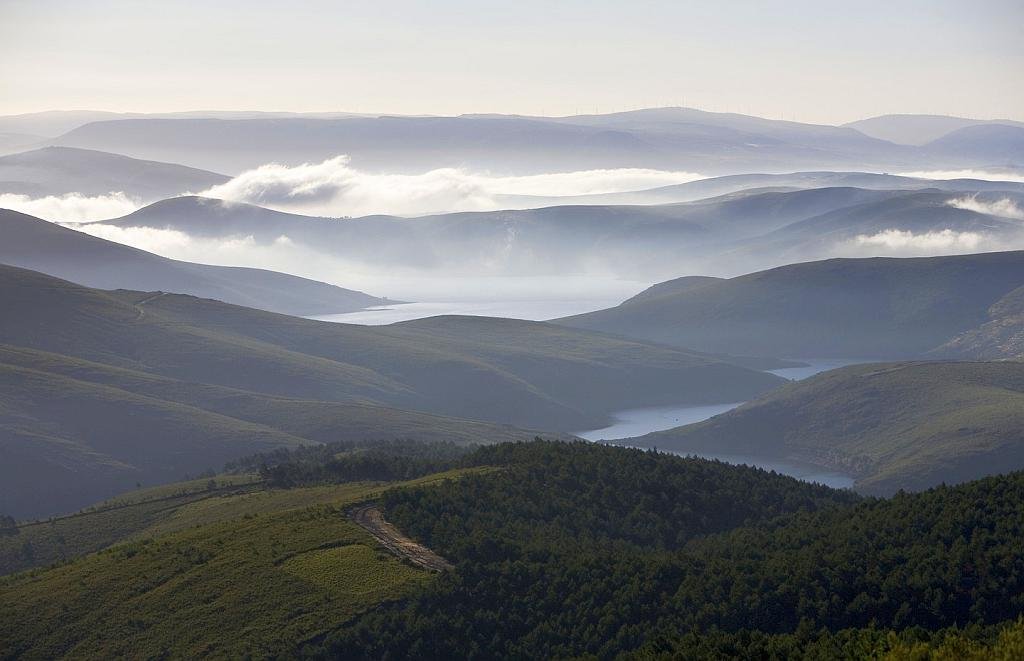
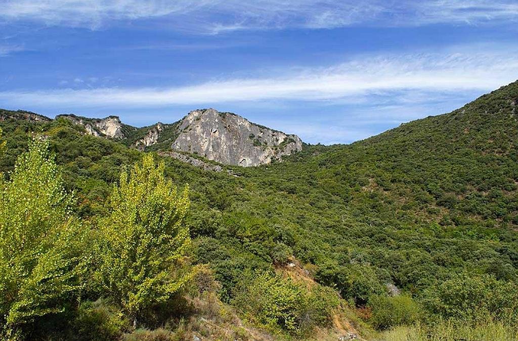
The Serra da Enciña da Lastra Natural Park is a protected area that includes the surroundings of the Serra da Enciña da Lastra mountains and a limestone valley with steep slopes and cliffs, including the pena (rock) falcoeira , the Inferno valley (val do Inferno) and the penedos de Oulego (Oulego cliffs).

This area holds the the largest area of ​​oak forest in Galicia. The river Sil flows for about four kilometers along the eastern end of the park and in is damned to create the Penarrubia reservoir.

The highest points of the mountain range are O Piornal at 1529 meters and the Pena Tara at 1089 meters on the cliffs of Oulego.

There are outstanding holm oak woods, ancient chestnut groves and Mediterranean scrubland with fields of wild thyme and flowering plants endemic to limy soil and more than 25 species or orchid. The gorges and sheer river passes are the habitats of birds of prey and other birds which make the park an interesting ornithological refuge. It has the largest concentration of nesting birds in Galicia and there are also large colonies of bats residing in the caves.

Some areas of the Serra da Enciña da Lastra Natural Park have restricted access. It is important to ask in the information centre if any of the routes that you want to walk requires a permit or is closed depending on the time of year.

Find a hotel close to the Serra da Enciña da Lastra Natural Park

Booking.com

Flora

This is a true A botanists delight with more than 450 species of vascular flora is known in the area with many plants local to the region and a least 40 species are endemic to the Iberian Peninsula. Six are from Galicia: Armeria rothmaleri, Campanula adsurgens, Dianthus merinoi, Leontodon farinosus, Petrocoptis grandiflora, Rhamnus pumila subspecies legionensis.

Orchids are well represented with around 25 species with 6 being endemic to Galicia. Among the different species, are those of the genus Ophrys, which simulate the body of a bee. The Orchis italica Poir develops numerous populations of great showiness. Some of the species, extraordinary from the point of view of their rarity at the Galician level, are the pyramidal orchid Anacamptis pyramidalis, Cephalanthera rubra, Limodorum abortivum and Orchis purpurea .

There is a special significanceof the plant communities attached to limestone rocks including Campanula adsurgens, Crepis albida subsp. asturica, Festuca burnatii, Leontodon farinosus and Petrocoptis grandiflora.

Fauna

The list of mammals in the Serra da Enciña da Lastra Natural Park is impressive with the presence of almost 50 species. This includes 9 species of bat such as the Mediterranean horseshoe bat (Rhinolophus euryale), Daubenton’s bat (Myotis daubentonii), Schreibers’s bat (Miniopterus schreibersii) and the European free-tailed bat (Tadarida teniotis).

Other mammals include wild cat (Felis sylvestris), otter (Lutra lutra), ermine (Mustela erminea), badger (Meles meles), European polecat (Mustela putorius), roe deer (Capreolus capreolus), wild boar (Sus scrofa) and Stone martin (Martes foina ).

Less common is the Iberian wolf (Canis lupus signatus), which appears to occur occasionally in the area.

Viewpoints (Miradores) in the Serra da Enciña da Lastra Natural Park

  • Alto da Escrita-Biobra (807 m). Views of the valley of the Galir and the river Sil with impressive cliff formations.
  • A Petada-Oulego (760 m). A Beautiful view of Oulego.
  • A Portela-Vilardesilva (640 m). Spectacular view of Vilardesilva and the cliff of Penarrubia.
  • Caprada north of Oulego (820 m). Stunning view of the north face of the Penedos de Oulego.
  • Fuente N-120-Covas (560 m). View of the Covas valley and the river Sil.
  • Pardollán (540 m). View of the Sil valley in Penarrubia and Pardollán.
  • Tanque-Covas (647 m). The best place in the Park to see birds of prey as from here as you can see the Pena Falcueira. Pena Falcueira has restricted access because it is a reserve area of ​​the Park.
  • Tunnel N-120-Covas (540 m). View of the Covas valley and the river Sil.
  • Valdesalvador-Biobra (800 m). View of the Galir valley and Serra Malvela.

Hiking and walking in the Serra da Enciña da Lastra Natural Park

Ruta Valle del Sil – Low / Medium – 1.30 h – 5 km – Linear
The route begins in Vilardesilva, in the viewpoint of A Portela (640 m), with a splendid panorama of the rural nucleus seated in a slope in balcony on the dam of Penarrubia, at the foot of an immense cut limestone.

Ruta Tras os Penedos – Low – 25 min – 1.5 km – Circular
The route begins in the rest area of ​​Caprada and has a beautiful panorama of the northern slopes of the impressive Penedos de Oulego.

Ruta Soutos baixo Pena Falcueira – Medium / High – 1.45 h – 3.9 km – Circular
The

This route begins in the viewpoint area of Tanque (647 m), from which we see a magnificent panorama of the village of Covas

Ruta del “Caleiro” – Med / High – 3 h – 6 km – Linear
The route begins in the lower part of the village of Vilardesilva, along a community path that descends between fields, chestnut groves and pastures with herds of goats. The path descending towards the river gives a magnificent panoramic view of the dammed river Sil.

Ruta de O Real de Oulego – Med – 2.30 h – 4 km – Linear
The path starts in Oulego in the rest area of ​​A Ponte, next to the river Galir and takes you through vinyards and meadows. Take the left along an agricultural road and then cross the two wooden pontoons (Pontón de Lavegos and Pontón de Real de Oulego).

Ruta de la Vía Romana – Med – 3.30 h – 8.6 km – Circular
The path starts in a recreational area next to the river Galir, taking in the direction of the cemetery. Take the first detour to the left to Alto do Coiñal through a section of the Roman road that connected Astorga and Braga. This first section is characterized by crops, cork oaks, scrubland, heaths and meadows

Ruta de la Ermita de Santo Estevo – Med – 3 h – 6 km – Circular
In the rest area near Pardollán strart the walk towards the village. This takes you through forest landscape to the hermitage and mills

Information/Visitors Centers

Centro de Visitantes del Parque Natural Serra da Enciña da Lastra

Address: Praza dos Bolos, s/n. Biobra

This is a really well presented information center with ample information about what makes Enciña da Lastra a unique and special part of Galicia.

The staff are very well informed and can help with walking routes (See above), history, flora and fauna of the area.

Serra da Enciña da Lastra Natural Park - Visitor Centre
Serra da Enciña da Lastra Natural Park – Visitor Centre

Summer Hours (May 1 to September 30, Tuesday through Sunday)
Morning: 10:30 – 14:00 / Afternoon: 16:00 – 19:30
Closed on Monday

Winter Hours: (March 15 to April 30 and October 1 to November 15 Friday through Sunday)
Morning: 10:30 – 14:00
Closed on Thursday


Iberia Nature Forum

Struggling with identifying those bugs and beasties? Why not check out the Iberia nature Forum!

Discover the Iberia Nature Forum – Environment, geography, nature, landscape, climate, culture, history, rural tourism and travel.

Monte o Invernadeiro Natural Park

  • Region: Galicia
  • Province: Orense
  • Declared a Natural Park: 1997
  • Park surface area: 5722 hectares
  • Towns and Villages: Villarino de Conso

Points of interest

The high mountains of the Monte o Invernadeiro Natural Park can only be described as stunning with its peaks and valleys covered in grasses, large extensions of scrub, woodland and riverside habitat. The area receives maximum protection and admits a maximum of just 30 visitors per day so a permit from the park authorities is required in order to enter the protected area. (Ask about this in your hotel or other accommodation, maybe they can get the permits for you.)

The park has several interesting trails of biological, geological and cultural interest. Some are the Valdeirexa or Cercados route, the Aceveda route, the A Troitas route, the A Agua route, the A Corga route and the Ortiga route

Find a hotel close to the Monte o Invernadeiro Natural Park

Booking.com

Flora

The park’s endemic forests are slow-growing and typical of mountain climates. The species that form them and are more abundant are oaks (Quercus robur, Quercus pyrenaica, Quercus petraea). The oak groves are found mainly in the avesedos and valgadas areas and mixed in with them and also found in other areas are holly (Ilex aquifolium), hazel (Corylus avellana), ash (Fraxinus excelsior), hazelnut (Corylus avellana), Alder buckthorn (Frangula alnus), birch (Betula celtiberica), yew (Taxus baccata), willow (Salix caprea), blackthorn (Prunus spinosa), Sycamore (Acer pseudoplatanus). There are also plantations of various pine species scattered around.

In higher areas species like Erica australis subsp. aragonensis can be seen, and at slightly lower altitudes Genista tridentata. In the rocks and crevices endemisms like Armeria ciliata or Dianthus langeanus are present.

In the shady areas of the forests there is a wealth of ferns and endemics plants such as Aphanolejaeunea microscopica, Anemone trifolia subspecies albida and Eryngium duriaei subspecies juresianum

Fauna

There are various species of amphibians and reptiles to look out for such as Iberian frog (Rana iberica), European common frog (Rana temporaria) and Iberian tree frog (Hyla molleri). Some of the reptiles are Iberian rock lizard (Iberolacerta monticola), Shreibers green lizard (Lacerta schreiberi). The ocellated lizard (Timon lepidus ibericus), Iberian wall lizard (Podarcis hispanica), Bocage’s wall lizard (Podarcis bocagei ), Smooth snake(Coronella austriaca), Seoane viper (Vipera seoanei), Latastes viper (Vipera latastei), viperine water snake (Natrix maura) and grass snake (Natrix natrix)

The Iberian wolf is present here with a stable population and they feed on wild ungulates such as roe deer, red deer, Spanish ibex, wild boar,and the Iberian hare. Other mammals present are wildcat (Felis silvestris), Stone marten (Martes martes), ermine (Mustela erminea), European polecat (Mustela putorius), otter (Lutra lutra), badger (Meles meles), genet (Genetta genetta), and fox (Vulpes vulpes).

Regarding the avifauna present, more than 80 species have been recorded and more than 60 breeding in the area such as golden eagle (Aquila chrysaetos), Eagle owl (Bubo bubo), Hen harrier (Circus cyaneus), Montagu’s harrier (Circus pygargus), Bonelli’s eagle (Hieraaetus fasciatus), Egyptian vulture (Neophron percnopterus), Grey partridge (Perdix perdix subsp. hispaniensis), Common redstart (Phoenicurus phoenicurus), Bluethroat (Luscinia svecica), Tawny pipit (Anthus campestris), little owl (Athene noctua), Tawny owl (Strix aluco), Long-eared owl (Asio otus), Short-toed snake eagle (Circaetus gallicus), peregrine falcon (Falco peregrinus ), Northern goshawk (Accipiter gentilis), common buzzard (Buteo buteo) and Eurasian sparrowhawk (Accipiter nisus).

Geological interest

Within the park there are several places of geological interest. Some are glacial circuses (at the head of Corga de Aguacenza, in Morrón dos Salgueiros and in Fial das Corzas), others are folds (such as the confluence of A Corga Cenzoá and Ribeira Grande, or the head of Corga da Ortiga), terraces (the alluvial of Ribeira Grande) or embankments (the end of the Ribeira Pequena), others are colluviums (like the one of the Corgo das Cembas-Ribeira Grande) and other waterfalls (like the waterfall and Cristas de Corgo da Buraquiña). Fossil sites are also present , such as those of A Ortiga, Altos do Cernado and O Cernado.

Information/Visitors Centers

Centro de recepción del Parque Natural de O Invernadeiro

The best place to head for is the Centro de recepción (main visitor centre) del Parque Natural de O Invernadeiro reached via the OU-114 from Verín, turning off on a signposted forest track which leads to the entrance.
(Ribeira Pequena, s/n. 32547 Vilariño de Conso)

Permits can be be obtained in advance from the Servizo de Conservación da Natureza de Ourense Rúa do Paseo, 18 – 5º. Ourense.
Tel: 988 386 376 – 988 386 029
E-mail: servizo.conservacion.natureza.ourense@xunta.es

Don’t miss the opportunity to visit Ribeira Grande’s Interpretation Centre even if you are unable to get a permit to enter the restricted area as it features the Ruta dos Cercados (Enclosures). This is a great footpath through natural habitat taking you past various enclosures containing red deer, spanish ibex, fallow deer, chamois and mouflon.

The official website for the Monte o Invernadeiro Natural Park is here: https://www.turismo.gal/que-visitar/espazos-naturais/parques-naturais/o-invernadeiro


Iberia Nature Forum

Struggling with identifying those bugs and beasties? Why not check out the Iberia nature Forum!

Discover the Iberia Nature Forum – Environment, geography, nature, landscape, climate, culture, history, rural tourism and travel.

Baixa Limia-Serra do Xures Natural Park

  • Region: Galicia
  • Province: Orense
  • Declared a Natural Park: 1993
  • Park surface area: 20,920 hectares
  • Towns and villages: Entrimo, Lovios, Muiños, Bande, Olelas, A Terrachá

Points of interest

The Baixa Limia-Serra do Xures Natural Park and, on the Portuguese side of the border, the Peneda-Gerês National Park are now joined to create the Gerês-Xurés Transboundary Biosphere Reserve (RBTGX) With an area of ​​267,958 ha, of protected territory in two natural spaces divided between Spain and Portugal.

On the Spanish side the stunning scenery, the towns and small villages such as Casola are a delight to discover. The A Fecha waterfalls are well worth a visit and whilst you are out and about look out for the “Cachena” cows, a small breed with huge horns that are native to the area and which in recent years have been rescued from the danger of extinction by various breeding programmes.

The spa town of Lobios, with its thermal waters from the river Caldo holds Roman remains of the mansio Aquis Originis and Aquis Querquernnis is a Roman site made up of a camp and a mansio viaria located on the banks of the As Conchas reservoir in the village of Bande.

The Lindoso reservoir in the central area of ​​the park between Entrimo and Lobios , and the Salas river reservoir, in Muíños in the east of the park are well worth the visit and another smaller reservoir is the Olelas in the A Corga do Porto do Medio irrigation canal, a tributary of the Castro Laboreiro river located in Entrimo.

Flora

The Baixa Limia-Serra do Xures Natural Park is a transitional area between Euro-siberian flora (Atlantic) and that of the Mediterranean and combined with altitude factors holds a diverse array of plantlife with scrubland on the peaks and forests of oak and other species in the valleys along with important riverside woodlands. The flora of the park is characterized by a deciduous forest, with Pyrenean oak (Quercus pyrenaica), birch (Betula celtiberica) and Mediterranean elements such as strawberry tree and holly. There are several endemic plants such as the Portuguese laurel (Prunus lusitanica) which is a species that colonizes ravines and other areas of high humidity.

Other interesting plantlife some on the endangered list for the area are: Arabis juressi, Armeria humilis subsp. odorata, Christella dentata, Eryngium duriaei subsp. juresianum, Iris boissieri, Prunus lusitanica, Ranunculus bupleuroides, Selinum carvifolia subsp. broteri, Sedum pruinatum, Serratula legionensis, Silene marizii, Spiranthes aestivalis, Thymelaea broteriana and Veronica micrantha.

Find a a hotel in the Baixa Limia-Serra do Xures Natural Park

Booking.com

Fauna

There is a healthy population of Iberian wolf in this area and their prey such as wild boar, red deer and Spanish Ibex.

Look out for the Galician pony or garrano, reintroduced into the region under a programme of recuperation of native species. There are also healthy populations of wildcat, the genet, otter, hare, rabbit and mink.

30 species of amphibians and reptiles have been recorded in the area including golden-striped salamander (Chioglossa lusitanica), large psammodromus (Psammodromus algirus), ladder snake (Zamensis scalaris) and latastes viper (Vipera latasti).

Baixa Limia-Serra do Xures Natural Park is also a special protection area for birds (ZEPA) thanks to its richness in birdlife and stands out for the typical Mediterranean and mountain species of Euro-Siberian regions (and for the species present in the two reservoirs of the park). Look out for golden eagle (Aquila chrysaetos), eagle owl (Bubo bubo), Hen harrier (Circus cyaneus), Montagu’s harrier (Circus pygargus), Common snipe (Gallinago gallinago), Bonelli’s eagle (Hieraaetus fasciatus), Red kite (Milvus milvus) and Egyptian vulture (Neophron percnopterus).

Not to miss in the Baixa Limia-Serra do Xures Natural Park

  • The mámoas road, which runs through the Leboreiro mountain range and where the Xurés, the Quinxo and the Peneda can be seen. In its heights the necropolises, the tombs and mámoas stand out.
  • A Queguas, where the megalithic remains of the Casa da Moura are located.
  • Padrendo, to see the plain of the Chan do Ventoselo and the mountains of Santa Eufemia and the Xurés.
  • Hermitage of Xurés, between valleys of the Vilameá and the Mine of the Shadows (Mina das Sombras) where the summits with impressive granite formations and the mining operation can be seen.
  • The Corga da Fecha, which goes from the thermal village of Lobios to the Ponte Nova following the Roman Via Nova.
  • Vilameá river, where the mills of this river and an alvariza stand out.
  • From Cela to Pitões, a route that goes up from Cela to Portela de Pitões.

Information/Visitors Centers

The emphasis in the tourist offices in this area is mainly about the roman history. There are some fascinating museums and information points in various towns and villages.

Centro de Interpretación “Aquae Querquennae Via Nova

The main offices of the Interpretation Centre for the Baixa Limia-Serra do Xures Natural Park are easy to find, located in the spa town of Lobios

Aquis Quequennis Complejo Arqueológico Romano

For Roman history a vist to the Archaeological Roman Complex is highly recommended.
Website: https://eng.querquennis.com/centro-de-interpretacion/

The official tourist website for the area is here: https://www.turismo.gal/que-visitar/espazos-naturais/parques-naturais/parque-natural-baixa-limia-serra-do-xures?langId=en_US


Iberia Nature Forum

Struggling with identifying those bugs and beasties? Why not check out the Iberia nature Forum!

Discover the Iberia Nature Forum – Environment, geography, nature, landscape, climate, culture, history, rural tourism and travel.