- Region: Madrid and Castilla y León
- Province: Madrid and Segovia
- Declared a National Park: 2013
- Park surface area: 33, 960 hectares
- Towns and Villages: (Madrid) Alameda del Valle, Becerril de la Sierra, Canencia, Cercedilla, El Boalo, Guadarrama, Los Molinos, Lozoya, Manzanares el Real, Miraflores de la Sierra, Navacerrada, Navarredonda y San Mamés, Pinilla del Valle, Rascafría, Soto del Real. (Segovia) Aldealengua de Pedraza, Basardilla, Collado Hermoso, El Espinar, Gallegos, La Losa, Navafría, Navas de Riofrío , Ortigosa del Monte, Otero de Herreros, Palazuelos de Eresma, Real Sitio de San Ildefonso, Santiuste de Pedraza, Santo Domingo de Pirón, Segovia, Sotosalbos, Torre Val de San Pedro, Torrecaballeros, Trescasas.
Points of interest
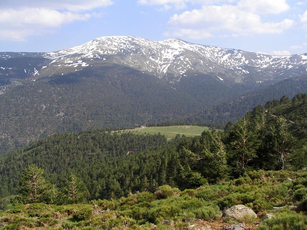
Not without it’s controversy over the years (due to it conflicting with housing and other human development plans), the Guadarrama National Park project was finally declared in 2013.
Its aims are to protect the eleven different ecosystems present in the Guadarrama mountains, including the only Iberian examples of “high Mediterranean mountain”. There are almost 1,300 different animal species in the area of which 13 are in danger of extinction. The species of animals in the mountains represent 45% of the total fauna of Spain and 18% of European fauna. There are mammals such as deer (red, roe and fallow), wild boar, Spanish Ibex, badgers, several mustelidaes, wild cats, foxes, hares, etc. Iberian wolf also seems to have returned to the area after a 70-year absence..
Also present are many species of waterfowl in the reservoirs and iconic raptors such as the Spanish imperial eagle, Golden eagle and Eurasian black vulture.
More than 1,500 native plants and 30 different types of vegetation habitat exist in the Guadarrama National Park and vegetation features Scots pine, oak, juniper and many other species.
Guadarrama National Park (Spanish Documentary) showing the wildlife and sceneries in the area.
Well worth watching (even if you don’t understand Spanish) for the great photography, wildlife and sceneries of the Guadarrama national Park
Find a hotel close to the Guadarrama National Park
[booking_product_helper shortname=”guadarrama national park (madrid)”]

The Guadarrama National Park has an excellent website for researching before you visit the area. Check out the official website here…
https://www.parquenacionalsierraguadarrama.es/en/
I absolutely love this video of an artist drawing the Guadarrama national park with a narration telling you about the area. (In Spanish)
Guided tours and activities around the Guadarrama national park
Lookouts and viewpoints (Miradors)
These are the best places to head for as they are normally in places of outstanding natural beauty and have information panels and accesses to footpaths etc. The below information is taken from the official website for the Guadarrama National Park. (I haven’t changed or corrected any of the text)
Rascafría
Los Robledos Viewpoint
Spectacular viewpoint and monument dedicated to the Forest Guards First Centenary. The access is through a paved detour from the M-604 road direction Los Cotos, slightly before getting to La Isla recreation area. A parking lot is available. From that natural promontory, the views of El Paular intermountain valley are just splendid. The valley is bordered by the Mounts Carpetanos and Cuerda Larga, with the Peñalara massif at the back. It is one of the most remarkable natural viewpoints of the whole Lozoya Valley.
La Gitana Viewpoint, Los Cotos Pass
Mirador de La Gitana
It is an easy accessible viewpoint from the Puerto de Los Cotos railway station, and from the same name parking lot. At the viewpoint, a large stretch of Cuerda Larga can be contemplated. There is as well a sundial allowing learning the solar time, and an “orienting aid” dedicated to the poet Federico García Lorca in order to facilitate the surrounding heights identification. Slightly earlier, and just in front of the Peñalara Visitors Center, is located as well El Príncipe viewpoint.
Manzanares El Real
Quebrantaherraduras Viewpoint, La Pedriza
The viewpoint is easily accessible in about 100 m through the path PR-M16 direction Sierra de los Porrones, detour taken at the Quebrantaherraduras track, located at La Pedriza road. At this point, the panorama opens to the captivating La Pedriza landscape, one of the larger Europe granitic ensembles. From a Peripheral perspective it is possible to observe Los Porrones north slope, La Maliciosa summit, La Bola del Mundo, Cuerda Larga ridge and La Pedriza Posterior and Anterior. At the viewpoint, you may contemplate Cuerda Larga ridge, La Pedriza Posterior with a cirque shape, La Pedriza Anterior crowned by El Yelmo, and slightly emerging, La Camorza Gorge where runs the Manzanares river looking for its exit to the reservoir.
El Collado de los Pastores Viewpoint, La Pedriza
From the last Canto Cochino parking lot, at the end of La Pedriza road, the viewpoint is accessible through the forest path Las Zetas, after a zigzagging 5 hours hike. An alternative and more direct option is to leave Las Zetas path after 3 km and take Los Chorros del Río Manzanares path, just before The French Bridge (Puente de los Franceses), and up to The Manchegos Bridge (Puente de los Manchegos), and then to climb through the path the last km up to the viewpoint. At this point, you may overlook one of La Pedriza densest pinewoods extensions, La Maliciosa summit, Los Porrones ridge, Cuerda Larga rounded heights, La Pedriza abrupt landscape with its whimsical forms, and at the bottom the Santillana reservoir leading to the Castilian meseta.
Navacerrada
Las Canchas Viewpoint
Las Canchas is La Barranca Valley viewpoint. It is accessible after an hour and half or a 2 hours hike, from the parking lot located at the end of the paved path issued from the M-607 road at 57 km, just after the Navacerrada entrance roundabout. After about a 20 minutes’ walk from the parking lot, there is a panel at the left side indicating the Ortiz Path (Senda Ortiz) detour, climbing the slope. After crossing a watercourse and reaching a wide meadow, the Ortiz path continues to the right joining the itinerary initial forest path and leading to the viewpoint 1 km further. At the spot it is possible to contemplate with an astonishing proximity the antenna at Las Guarramillas Peak and the ridge spread out from that summit up to La Maliciosa Peak.
Cercedilla
Mirador aleixandre
From La Fuenfría Valley parking lots, and following the orange spots at the trees, you may access to the Vicente Aleixandre and Luis Rosales viewpoints. In 1984, year of Vicente Aleixandre’ death, it is inaugurated at La Fuenfría Valley the viewpoint after him. Following the poets path, all of it chiseled with poems of Antonio Machado and José García Nieto among other, you will reach the Luis Rosales viewpoint. From those viewpoints it is possible to observe the Siete Picos wall, the Marichiva Col, La Peñota, Montón de Trigo, part of the narrow gauge train railway, and especially a panoramic view of many Sierra villages such as Guadarrama, Los Molinos and Cercedilla. Also might be contemplated Navalmedio and Valmayor reservoirs, El Escorial mounts and the City of Madrid on clear days.
El Lanchazo, La Calva or De La Reina Viewpoint
It is possible to access the viewpoint from La Fuenfría pass, descending La República road about 800 m. Another option is to ascend about 8 km through La República road, from the Majavilán parking lot.
La Fuenfría Valley is an emblematic viewpoint, visible from many spots of the valley, due to its wall built on stone and the also stone enormous longboat (Lancha). That is why it is also called “El Lanchazo”. Spectacular views of the whole La Fuenfría Valley can be observed, and as well its characteristic upside down bag shape. It is also possible to see some other Valley spots, like La Fuenfría Hospital or La Peñota, Peña Aguila and Marichiva heights.
Information/Visitors Centers
There are 5 official visitor interpretation centres and each one is well worth a visit.
Peñalara Visitors Center in Rascafría (Madrid)
Ctra. M-604, Km 42. Puerto de los Cotos. Rascafría
Valle de la Fuenfría Visitors Center in Cercedilla (Madrid)
Ctra. de las Dehesas, km 2 Cercedilla
La Pedriza Visitors Center in Manzanares El Real (Madrid)
Camino de la Pedriza, s/n Manzanares El Real
Valle de El Paular Visitors Center in Rascafría (Madrid)
Ctra. M-604 km 27,6 Rascafría
Valsaín Visitors Center (Boca del Asno) – La Granja de San Ildefonso (Segovia)
Ctra CL- 601 km 14,3 Valsaín
The official website for the Guadarrama National Park is here: https://www.parquenacionalsierraguadarrama.es/en/
Ronda Today
Everything you need to know before you visit Ronda “The city of dreams” in Andalucia. https://www.rondatoday.com/
Visit Cádiz
Planning on visiting Cádiz? Tourist information. Monuments. Hotels. Activities. City guides: https://visitingcadiz.com/
The Caminito del Rey
Find tickets for the Caminito del Rey: https://www.caminodelrey.es/
Wildside Holidays – Spain
Take a trip on the Wildside! Discover the wildlife and nature of Spain, its Natural and National Parks and find the top wildlife, activity and walking holiday companies.
Iberia Nature Forum
Discover the Iberia Nature Forum – Environment, geography, nature, landscape, climate, culture, history, rural tourism and travel.
I’ve been living in this lovely area of Western Andalucia for the last 20 years or so and dedicate most of my time to the running of English language tourist information websites for the towns of Cádiz, Ronda, Grazalema, the famous or infamous Caminito del Rey, and also Wildside Holidays, which promotes sustainable and eco-friendly businesses running wildlife and walking holidays in Spain. My articles contain affiliate links that will help you reserve a hotel, bus, train or activity in the area. You don’t pay more, but by using them you do support this website. Thankyou!