Montaña Palentina Natural park

Montaña Palentina Natural park
  • Region: Castilla y Leon
  • Province: Palencia
  • Declared a Natural Park: (Fuentes Carrionas and Fuente Cobre-Montaña Palentina Natural Park) 1992
  • Renamed and expanded: (Montaña Palentina Natural park) 2000
  • Park surface area: 78,360 hectares
  • Towns and villages: Aguilar de Campoo, Brañosera, Castrejón de la Peña, Cervera de Pisuerga, Dehesa de Montejo, La Pernía, Polentinos, Triollo, Velilla del Río Carrión, San Cebrián de Mudá

Points of interest

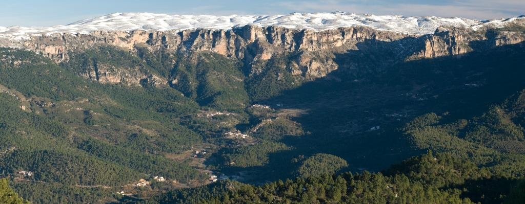
The Montaña Palentina Natural Park (formerly called Fuentes Carrionas y Fuente Cobre-Montaña Palentina Natural Park) is a protected area located in the north of the province of Palencia. The Palentina Mountain range is home to the Fuentes Carrionas and Fuente del Cobre which are the sources of the Carrión and Pisuerga rivers.

This is a space of great natural, landscape, fauna and botanical value. It has the most northern mass of junipers in Europe, together with endemic species from the Cantabrian Mountains such as the Cantabrian Artemis and the Echium cantabricum.

Read more

The Serranía de Cuenca Natural Park

The Serranía de Cuenca Natural Park
  • Region: Castilla la Mancha
  • Province: Cuenca
  • Declared a Natural Park: 2007
  • Park surface area: 73,726 hectares
  • Towns and villages: Arcos de la Sierra, Beamud, Cuenca, Huélamo, Portilla, Tragacete, Uña, Valdemeca, Villalba de la Sierra, Zafrilla.

Points of interest

The Serranía de Cuenca Natural Park is located in the northeast of the province of Cuenca and within the mountain range of the same name. (The area known as the Serranía de Cuenca itself is much larger and is within the provinces of Cuenca, Guadalajara and Teruel).

The protected area is close, at its northwestern edge, to the Alto Tajo Natural Park. The Cuenca mountain range stands out for the existence of a very unique landscape, in which fascinating geological structures are numerous. This peculiar landscape, sculpted by water on calcareous rocks, is called karstic and its formation is due to the dissolution and/or precipitation of calcareous rocks.

Los barcos at the Ciudad Encantada
The scale of these formations can be seen when a person is also in the picture! In this case, my kids by “Los barcos” (The boats)

The area has also become famous as a starlight destination. The Starlight Foundation is a non-profit organization that was founded in 2009 to promote the protection of the night sky and the development of “astrotourism” and there is an ever growing list of starlight destinations in Spain to visit.

Read more

Calares del Rio Mundo y de la Sima Natural Park

Calares del Rio Mundo y de la Sima Natural Park
  • Region: Castilla la Mancha
  • Province: Albacete
  • Declared a Natural Park: 2005
  • Park surface area: 19,192 hectares
  • Place of Community Importance (SCI)
  • Special Protection Area for Birds (ZEPA)
  • Towns and villages: Yeste, Cotillas, Molinicos, Riópar, Víanos, Villaverde del Guadalimar and Veste

Points of interest

A mountainous terrain, the Calares del Rio Mundo y de la Sima Natural Park is marked by several watercourses that have eroded and created karst landscapes of great beauty across the Sierra de Alcaraz, Campo de Montiel and the Sierra del Segura . This park is close to the neighboring Natural Park of the Sierras de Cazorla, Segura and Las Villas in Andalucia.

The Mundo river is well known for its picturesque source. The river originates from a cave in the middle of a tall cliff and forms a waterfall with a height of almost 100 meters. Subsequently, it forms a series of smaller cascades and pools.

The area has also become famous as a starlight destination. The Starlight Foundation is a non-profit organization that was founded in 2009 to promote the protection of the night sky and the development of “astrotourism” and there is an ever growing list of starlight destinations in Spain to visit.

Read more

Lagunas de Ruidera Natural Park

Lagunas de Ruidera Natural Park
  • Region: Castilla la Mancha
  • Province: Albacete and Ciudad Real
  • Towns and villages: Argamasilla de Alba, Ruidera, Alhambra, Ossa de Montiel and Villahermosa.
  • Declared a Natural Park: 1979
  • Park surface area: 3,772 hectares
Points of interest

The Lagunas de Ruidera Natural Park acts as a buffer zone to the Tablas de Daimiel National Park and It consists of a complex lagoon system made up of fifteen lagoons, which over 30 kilometers constitute the Alto Guadiana valley and in its highest part the source of the Guadiana river.

A lot of activities are available in the area such as hiking, diving, kayaking, paddle surfing, sailing, etc. There are bathing areas during the summer, and good places for sport fishing (See below)

Read more

Related Posts
  1. Coolest Places To Stay In London
  2. Unusual Day Trips From London
  3. Things To Do In London On A Budget
  4. London Expensive
  5. Hidden Places In London
  6. London City Trip Planner
  7. Best Shopping In London England
  8. Transport In London
  9. Best London Neighborhoods For Families
  10. First Trip To London